
Big Picture Atlas


Big Picture Atlas
Big Picture Atlas Book Description
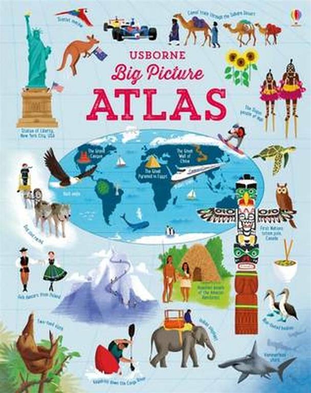
Readers will find Big Picture Atlas to be a fresh, visual journey through world cultures and geography. The book blends vivid maps with concise narratives, allowing curious minds to explore continents at a glance. Inside, each spread pairs stunning cartography with engaging facts, making complex topics easy to digest. Moreover, the design invites both casual browsing and deeper study, ensuring that every page offers something new to discover.
The story travels from bustling cities to remote landscapes, highlighting how people shape and are shaped by their environments. Fans of travel and education will enjoy the balanced mix of images and text. Meanwhile, educators can use the atlas as a classroom tool to spark discussions about history, climate, and cultural diversity. Additionally, the compact format fits easily on any shelf, encouraging frequent reference.
Throughout the book, the author uses clear language and vibrant illustrations to guide readers across borders. The themes of connectivity and curiosity run strong, reminding us that the world is both vast and intimately linked. Because each chapter focuses on a different region, readers can tailor their experience to personal interests or explore the entire globe in one sitting.
Key Features of Big Picture Atlas
First, the atlas offers high‑resolution maps that are both artistic and informative. Each map includes landmarks, major rivers, and population centers, helping readers visualize geographic relationships. Additionally, short sidebars provide bite‑size facts about languages, traditions, and wildlife, enriching the visual experience with context.
Second, the book is organized by continent and then by country, making navigation simple. Readers can flip directly to a region of interest without getting lost in dense text. Furthermore, the layout uses bold headings and icons, guiding the eye and improving readability for all ages.
Third, the author incorporates QR codes that link to interactive online resources. This feature lets readers expand on topics with videos, quizzes, and downloadable maps. Therefore, the atlas bridges printed and digital learning, offering a modern twist on a classic reference tool.
Why Read This Book?
Many readers seek a source that combines education with visual appeal, and this atlas delivers precisely that. It helps families plan vacations, students prepare for exams, and travelers gain quick insights before a trip. Because the content is concise yet thorough, it respects busy schedules while still delivering depth.
The book also encourages curiosity about the planet. Readers can compare climate zones, discover cultural festivals, and learn how geography influences daily life. Moreover, the engaging style makes learning feel like an adventure rather than a task.
Finally, owning Big Picture Atlas adds value to any personal library. Its durable cover and timeless content ensure it remains relevant for years. Whether displayed on a coffee table or used for study, the atlas becomes a trusted companion for a lifelong love of the world.
About This Book
For more details about this title and its author, visit the Goodreads page. You can also explore the best English books available at Kalimat Bookstore Online through our books collection. Discover the joy of exploration with Big Picture Atlas today.
Be the first to review “Big Picture Atlas”
Product Related
EGP200.00

EGP880.00

Out of stock
EGP455.00

EGP429.00
Reviews
There are no reviews yet.